
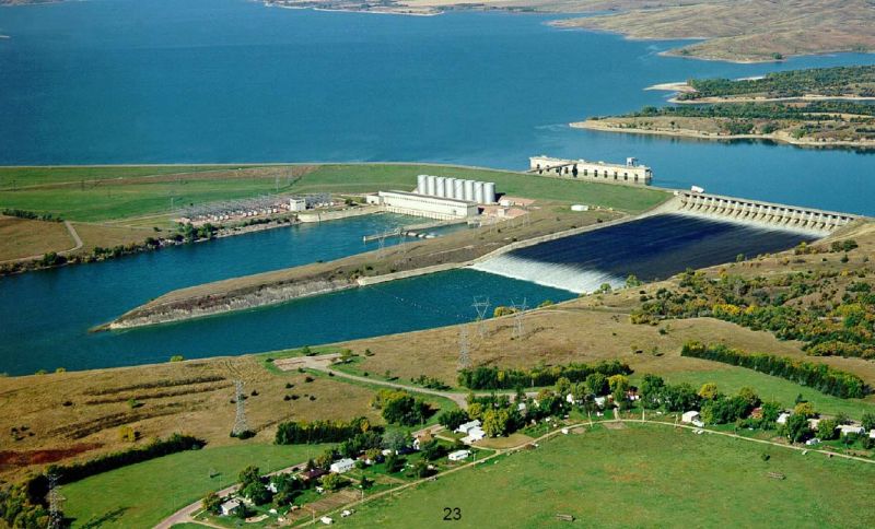
10. Lake Francis Case, South Dakota
Lake Francis Case, named after former South Dakota Senator Francis Higbee Case, has a total capacity of 3,800,000 acre-feet, stretches over 100 miles, has a shoreline of 540 miles, an area of 102,000 acres, and a maximum depth of 140 feet. It is impounded by the Fort Randall Dam on the Missouri River in south-central South Dakota and it provides water supply, hydroelectric power, recreation, and an abundant, rich habitat for local wildlife. In fact, Lake Francis Case is home to one of the largest wintering populations of bald and golden eagles.
Authorized by the Flood Control Act of 1944 and built next to Old Fort Randall, a military fort built in 1856, Fort Randall Dam is an earthen embankment dam that underwent construction by the Army Corps of Engineers in 1946. In 1954, President Dwight D. Eisenhower flipped the switch that started the first power generating unit, and the project was officially completed in 1956 at a cost of about $200 million.
9. Toledo Bend Lake, Louisiana and Texas
With a total area of about 205,000 acres in both Louisiana and Texas and providing water supply, hydroelectric power, and a plethora of recreational uses, Toledo Bend Lake is the largest human-made body of water in the south and the ninth largest in the United States. Impounded by the Toledo Bend Dam, Toledo Bend Reservoir has a storage capacity of 4,477,000 acre-feet, is 15 miles across at its widest point, has an average depth of 60 feet, is 1,264 miles of shoreline, and its two hydroelectric power generators have an estimated annual energy output of 205 million kilowatt-hours.
In 1949 and 1950 respectively, realizing a need to provide for the future, the Texas and Louisiana State Legislatures each formed their own Sabine River Authority in an effort to both conserve and develop the Sabine River Basin. In the 1950s, the two organizations worked together to come up with the idea of Toledo Bend Lake, and feasibility studies indicated that the project would be a success. Land acquisition and construction took place in the 1960s, and the project was completed in 1969. The total cost, including the land, dam and spillway, powerhouse, new roads and bridges, and the clearing of shorelines, was $70 million. Due to cooperation from investor-owned companies Gulf States Utilities Company, Louisiana Power and Light Company, and Central Louisiana Electric Company, the Toledo Bend Reservoir project did not have federal funding in its permanent financing – the only public water conservation and hydroelectric project to boast such a statistic.
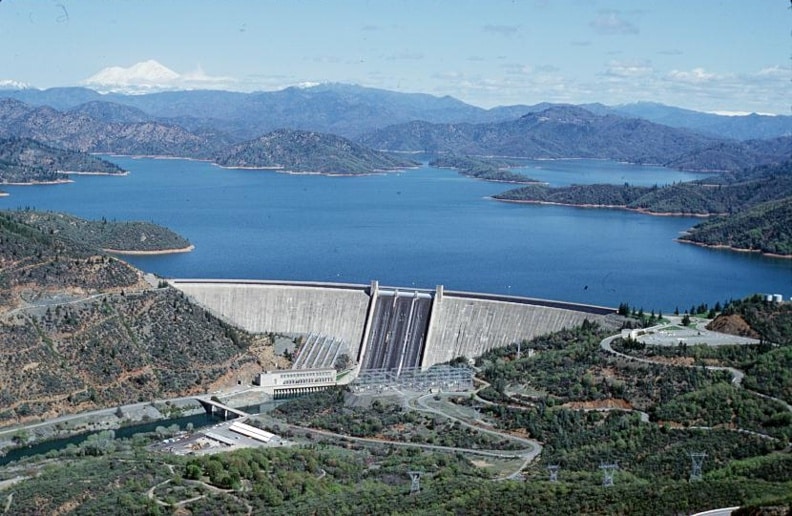
8. Lake Shasta, California
With a total capacity of 4,552,000 acre-feet, an elevation of 1,067 feet, 365 miles of mostly mountainous shoreline, and a maximum depth of 517 feet, Lake Shasta is California’s largest reservoir and the eighth largest in the United States. Lake Shasta is impounded by the Shasta Dam, a concrete arch gravity dam across the Sacramento River that stands 602 feet tall, making it the eighth tallest dam in the United States. Operated by the Bureau of Reclamation, the reservoir provides water storage, flood control, hydroelectricity, and protection against the intrusion of salt water.
The Shasta Power Plant contains five huge generators capable of producing 710 megawatts, and recent upgrades have increased their efficiency rating to 98%. Originally built to control the waters of the Sacramento, the McCloud, and the Pit Rivers, the reservoir has since become one of the most popular vacation spots in the western United States. Providing thousands of jobs for people still suffering from the Great Depression, construction on the dam began in 1935 and was completed in 1945.
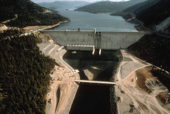
7. Lake Koocanusa, Montana
Impounded by the Libby Dam on the Kootenay River, Lake Koocanusa has a total capacity of 5,809,000 acre-feet, stretches 90 miles on the northern part of Montana and into British Columbia, Canada, and has a maximum depth of 370 feet. The reservoir provides water supply to both the United States and Canada, as well as hydroelectric power, flood protection, and wildlife habitat.
Operated by the Army Corps of Engineers in the United States, construction of the Libby Dam was a joint cooperative venture between the U.S. and Canada that began in 1966 and was completed in 1972. The Libby Dam is a concrete gravity dam that stands 422 feet tall and has a gated overflow spillway. The dam’s powerhouse contains five turbines and can generate up to 600 megawatts of power.
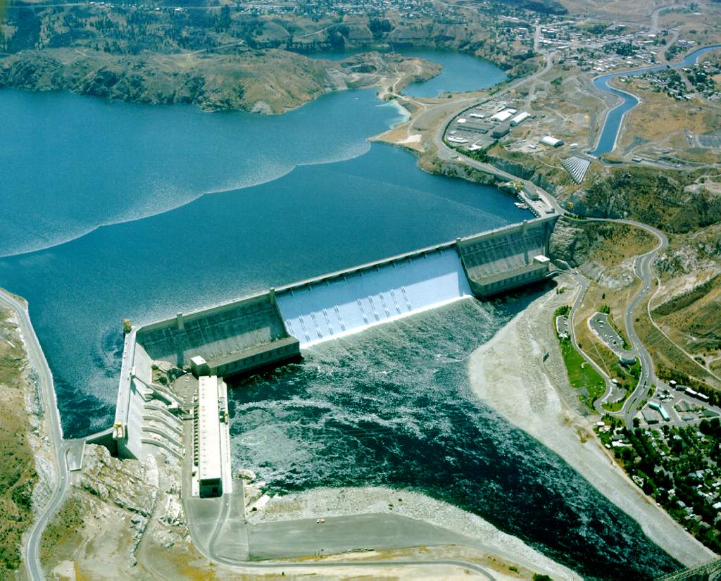
6. Franklin D. Roosevelt Reservoir (Lake Franklin), Washington
With a total capacity of 9,562,000 acre-feet, Lake Franklin is the largest reservoir and lake in Washington state and the sixth largest in the nation. Impounded by the Grand Coulee Dam on the Columbia River, Lake Franklin covers 125 square miles, has over 600 miles of shoreline, and stretches about 150 miles from the Canadian border to the Grand Coulee Dam. The reservoir provides water supply, hydroelectric power, wildlife habitat, and recreation.
Constructed between 1933 and 1941 and operated by the Bureau of Reclamation, the Grand Coulee dam is a concrete gravity dam that stands 550 feet tall, stretches almost one-mile long, and has a drum gate spillway. Originally constructed with two power plants, a third power station was added in 1974, and it is now the largest electric power-producing facility in the United States.
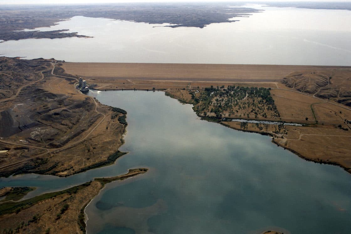
5. Fort Peck Lake, Montana
Boasting a 1,520-mile long shoreline that is longer than the entire coastline of California, Fort Peck Lake stretches 134 miles through central Montana, has a total capacity of 15,400,000 acre-feet, covers an area of approximately 245,000 acres, and has a maximum depth of 220 feet. Impounded by the Fort Peck Dam on the Missouri River, Fort Peck Lake provides water quality management, flood control, and hydroelectric power. It also lies within the Charles M. Russell National Wildlife Refuge and is home to a plethora of fish and game.
Operated by the Army Corps of Engineers, Fort Peck Dam was a major project of the Public Works Administration as part of the New Deal. The dam was constructed from 1933 to 1943 and the project employed tens of thousands of people. Fort Peck Dam is an art deco hydraulic earthfill dam that stands 250 feet tall, has a controlled overflow spillway with eight bulkhead gates, and has five generating units with a capacity of 185 megawatts. The dam was added to the National Register of Historic places in 1986 and is the largest hydraulically filled dam in the United States. It is also the second largest dam in the world by structure volume, second only to the Tarbela Dam in Pakistan.
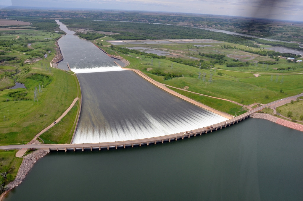
4. Lake Sakakawea, North Dakota
Impounded by the Garrison Dam on the Missouri River, Lake Sakakawea has a surface area of 307,000 acres, maximum depth of 180 feet, a shoreline of 1,320 miles, and a total capacity of 18,500,000 acre-feet. It is the largest human-made lake in North Dakota and the fourth largest in the United States. Originally constructed for flood control, navigation, irrigation, and hydroelectric power, the project was constructed by the Army Corps of Engineers between 1947 and 1953 and cost approximately $300 million.
Garrison Dam is an earthfill embankment dam that stretches almost two miles in length, stands 210 feet tall, generates 583 megawatts of power, and has a service spillway with 28 controlled gates. It is the fifth largest earthen dam in the world.
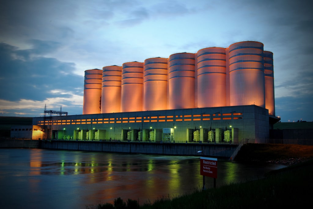
3. Lake Oahe, South Dakota
With a surface area of 374,000 acres and a total capacity of 19,300,000 acre-feet, Lake Oahe stretches for 231 miles through South Dakota and is the third largest reservoir in the United States. It provides flood control, irrigation, hydroelectric power, recreation, wildlife habitat, and navigation benefits,
Authorized by the Flood Control Act of 1944, the Oahe Dam underwent construction in 1948 by the Army Corps of Engineers. In 1952, the world’s first rock tunnel boring machine (TBM) was invented specifically for the Oahe Dam project. The significance of James S. Robbins’ TBM invention cannot be overlooked, as it marked the beginning of machines replacing humans for tunneling. The earthfill dam, which is 245 feet tall and 9,360 feet long, impounds the Missouri River, has eight spillways, and is the fifth largest dam in the world by structure volume. The power station is capable of generating 768 megawatts of power and provides electricity for most of the north-central United States. The project, which was completed in 1962 at a total cost of approximately $340 million, was officially dedicated by President John F. Kennedy.
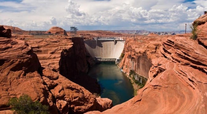
2. Lake Powell, Arizona
A breathtakingly beautiful reservoir that attracts over two million vacationers per year, Lake Powell is the second largest reservoir in the United States and is impounded by the Glen Canyon Dam on the Colorado River. Lake Powell — which has a capacity of 27,000,000 acre-feet, a surface area of over 161,000 acres, and a maximum depth of 532 feet — provides water storage for the Upper Basin states of the Colorado River Compact, including Colorado, Utah, Wyoming, and New Mexico.
Constructed at a cost of $155 million from 1956 to 1966 by the Bureau of Reclamation, the Glen Canyon Dam is a concrete arch gravity dam that stands 710 feet tall, contains over five million cubic yards of concrete, provides 1296 megawatts of power, and has twin concrete tunnel spillways controlled by double radial gates. The project was dedicated by Lady Bird Johnson on September 22, 1966.
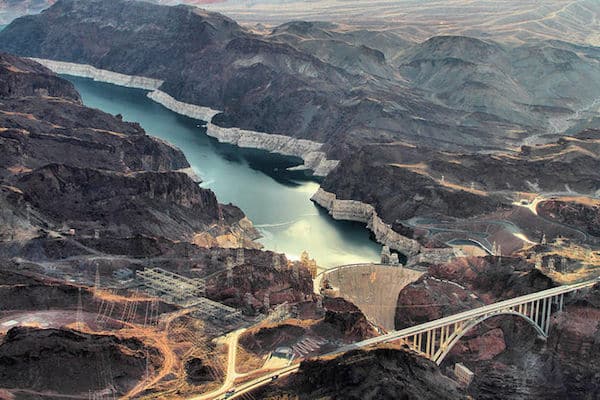
1. Lake Mead, Nevada
Named after Bureau of Reclamation Commissioner Elwood Mead, Lake Mead is the largest reservoir in the United States, stretching 112 miles long with a total capacity of 28,255,000 acre-feet, a shoreline of 759 miles, and a maximum depth of 532 feet. It provides water supply, hydroelectric power, recreation, and wildlife habitat. Because of prolonged drought and increased demand, Lake Mead — which provides water to over 20 million people in the states of Arizona, Nevada, and California — has not actually reached its full capacity since 1983. In fact, Lake Sakakawea, number four on our list, currently lays claim to the title of largest reservoir by total area and water volume in reserve.
Constructed between 1931 and 1936 by the Bureau of Reclamation at a cost of $49 million, the Hoover Dam impounds the Colorado River to create Lake Mead. As impressive as the reservoir it creates, the Hoover Dam is a concrete gravity arch dam that soars a whopping 726 feet tall, has two controlled drum-gate spillways, and generates an impressive 2,080 megawatts of power. The construction provided jobs for thousands and thousands of workers during the Great Depression and was named, if somewhat controversially, after President Herbert Hoover. It is the second tallest dam in the United States, second only to the Oroville Dam in California.