Tata & Howard was pleased to participate in the 2021 NEWEA Sponsorship Program and is grateful to be a supporter of NEWEA each year.


Tata & Howard was pleased to participate in the 2021 NEWEA Sponsorship Program and is grateful to be a supporter of NEWEA each year.
Introduction

New England is one of the oldest and most historically rich areas of the nation. Famous events such as the pilgrims founding Plimouth Plantation and Paul Revere’s midnight ride took place in Massachusetts. New Hampshire planted the first potato in America, Maine introduced the nation’s first sawmill, and Vermont produced the nation’s first gummed postage stamp. Connecticut has the most “firsts” of any state in the nation including the first newspaper, submarine, and hamburger, while tiny but mighty Rhode Island was the first colony in the nation to declare independence from Britain. New England also boasts another first: it is home to the nation’s first water distribution systems.
A Brief History

Boston, Massachusetts became home to the nation’s first waterworks in 1652. Distribution pipes at that time were made of wood, constructed from bored-out logs from the area’s plentiful hemlock and elm trees and attached together with pitch, tar, or iron hoops. While this rudimentary distribution system did supply some of the area’s residents, it was mainly used for fire protection as homes during that time — constructed of wood and heated with fireplaces —were particularly prone to fire.
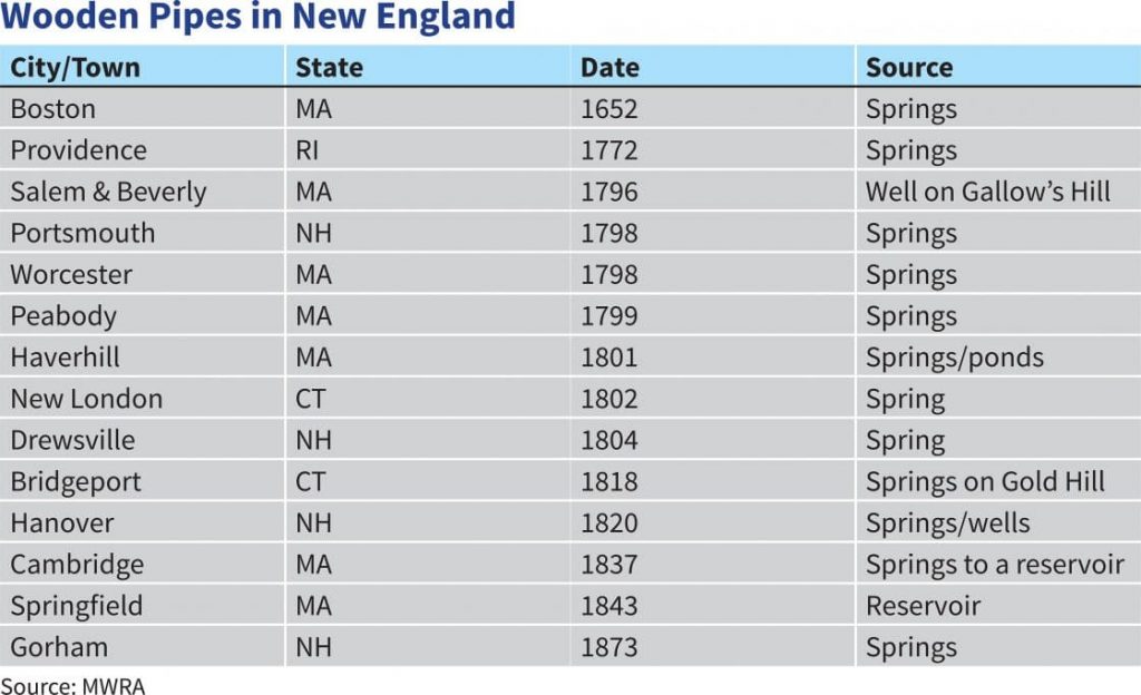
It was over a century before other New England cities began installing wooden distribution pipes. Providence, Rhode Island, Portsmouth, New Hampshire, and Worcester, Massachusetts all laid wooden pipes during the late 1700s, and several other cities followed suit in the early 1800s. Contrary to some urban myths, wooden pipes are not still in use in any areas of New England today. The high pressure from modern water systems would instantly split any existing wooden pipes. Wooden pipes that are occasionally unearthed during some construction projects were disconnected years ago.
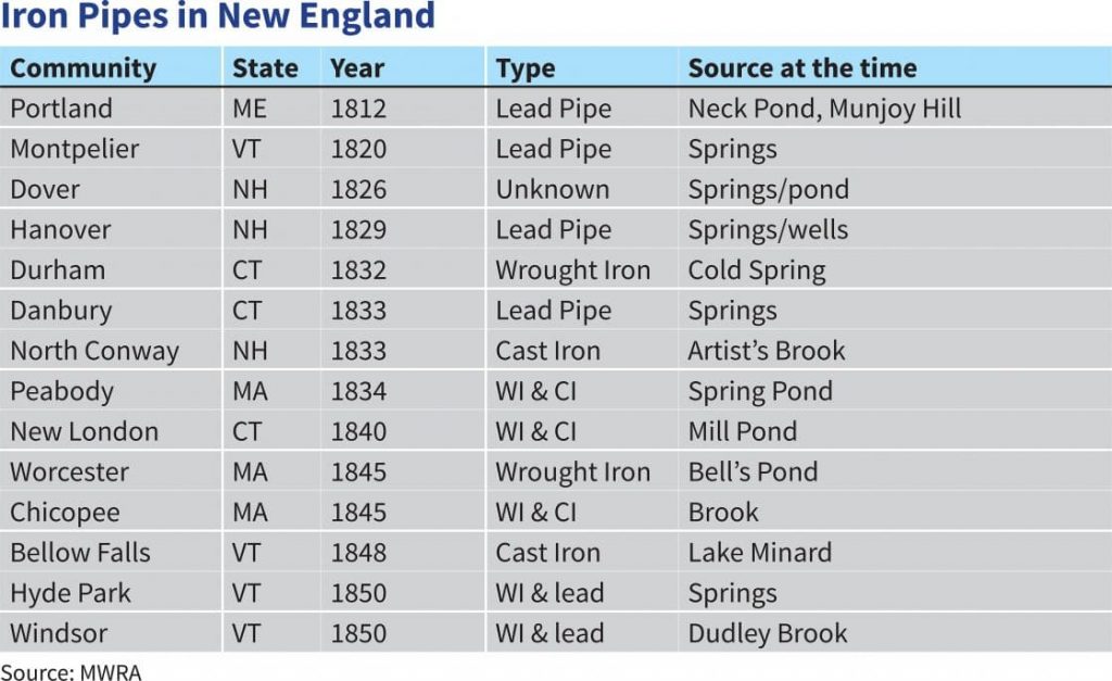
Wooden pipes were problematic for many reasons including warping and sagging, insect infestation, rotting, taste issues, and splitting. As iron became increasingly available during the early 1800s, cities began installing iron pipes. The first iron pipes in New England were installed in Portland, Maine in 1812, followed by Montpelier, Vermont in 1820, and in both instances the pipes were lead. Many other cities followed suit throughout the 19th century, utilizing wrought iron, cast iron, and lead pipe. In the 1950s, ductile iron piping was introduced and boasted the longevity of cast iron with the addition of increased strength, flexibility, and safety. It became widely used in the 1970s and it is still the material of choice throughout New England today.
Distribution Systems Today

New England can be considered a pioneer of our nation’s water infrastructure. After all, distribution systems have grown from a few wooden pipes in Boston to the intricate, complicated underground infrastructure that we enjoy today. However, because much of the area’s infrastructure was laid so long ago, it has reached the end of its useful life. Water main breaks occur daily and are not only inconvenient to customers, they can also be dangerous, as evidenced by the November 2016 water main break in Boston, Massachusetts that caused manhole fires and forced evacuation of the area. Maintaining and updating our distribution systems is critical to the health and safety of our nation, its people, and the economy. But with limited budgets and resources, where do we start?
Strategically prioritizing improvements is imperative to today’s water systems, as the rehabilitation and replacement of our nation’s buried infrastructure is an ongoing task. Asset management provides a roadmap for utilities, allowing them to maximize their limited infrastructure dollars by planning for the replacement of critical infrastructure over time. Tata & Howard’s Capital Efficiency Plan™ (CEP) methodology takes it one step further by combining the concepts of asset management, hydraulic modeling, and system criticality into a single comprehensive report. The final report provides utilities with a database and Geographic Information System (GIS) representation for each pipe segment within their underground piping system, prioritizes water distribution system piping improvements, and provides estimated costs for water main replacement and rehabilitation.
Since the firm’s inception in 1992, Tata & Howard has remained a niche firm with deep experience and expertise in the water environment, and has provided CEP and hydraulic modeling services for countless municipalities throughout New England. Tata & Howard has one of the largest pipe asset management databases of any consulting engineering firm in New England. In fact, we have data on over 5,000 miles of New England pipe, providing utilities with critical information about their systems such as condition and probability of failure of certain pipe cohorts.
In Conclusion
Water distribution systems have come a long way since the days of hollowed out logs providing fire protection to colonial Bostonians. The underground network of distribution pipes has grown astronomically and now incorporates safer, stronger, and more cost-effective materials. As distribution systems are updated and expanded, it is critical that accurate, up-to-date information is available to water systems so that they may invest their limited capital wisely.
 Memorial Day is the generally accepted start of summer to most New England communities. Pools are opened, grills are wheeled out from storage, flowers are planted, and beaches are officially opened. And while summer is absolutely breathtaking in New England, it is also a time of increased stress on water quality and supply.
Water Quality
Defined by the EPA as a sandy, pebbly, or rocky shore of a body of water, beaches provide recreation for approximately 100 million United States residents over the age of 16 each year. Families flock to beaches during the summer months to enjoy activities such as swimming, surfing, boating, fishing, parasailing, exploring, walking, and sunbathing. Beaches not only include the sandy expanses with boardwalks and cottage rentals along the coastline, but also lake and riverfront areas, ponds, estuaries, and lagoons, some of which are even found in urban areas. Beaches are also an integral part of the the United States economy and provide habitat to many species.
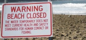 Unfortunately, because of the huge popularity of beaches in the summer, water quality can suffer. Beach closures are common during the summer months, and are a result of pollutants and pathogens entering the water. One of the most common sources of water pollution is human fecal matter from leaky septic systems and sewer overflows. Human waste contains a variety of harmful organisms, including bacteria, viruses, and parasites, that can cause illnesses such as gastroenteritis, hepatitis, and skin infection to humans. Another source of pollution is animal fecal matter from agricultural and stormwater runoff. While runoff contains a number of pollutants including motor oil, pesticides, fertilizers, and trash, arguably the most dangerous and disruptive is animal feces. A single gram of dog feces contains over 23 million parvovirus bacteria in addition to whipworms, hookworms, roundworms, threadworms, giardia, and coccidian. These pathogens and parasites enter waterways through runoff and can have detrimental effects on waterways, aquatic life, and humans.

Algal blooms are also more common in summer months. Algal blooms are caused by a variety of sources including warmer temperatures, high light, and increased turbidity, but the most contributive source is nutrients in the water from human and animal waste. Some algal blooms are extremely dangerous and have the potential to sicken or kill humans and animals, while less toxic blooms still cause harm to local economies and the environment. Commonly referred to as red tide, cyanobacteria, or blue-green algae, algal blooms effectively cause dead zones in the water and often require significantly increased treatment costs to remedy.
Water Supply
In addition to water quality issues at beaches, water supply can also be a concern. Since the population at popular vacation spots such as Cape Cod and the Maine beaches increases astronomically in the summer months, so does the demand for water. And not only are these seasonal visitors doing laundry, cooking, and drinking the water — they are also watering their lawns and gardens, which accounts for over half of a household’s total water usage. It is therefore understandable how a small community’s water supply can easily become taxed during the high summer season.
Solutions
 Fortunately, there are policies and regulations in place that directly address seasonal water quality and quantity issues. The EPA, along with other governmental agencies, have enacted several laws that aim to protect the quality of our nation’s beaches:
The Clean Water Act
The Clean Water Act, established by the EPA in 1971, establishes the basic structure for regulating discharges of pollutants into the waters of the United States and regulating quality standards for surface waters. Under the Clean Water Act, the following programs specifically address water pollution:
The National Pollutant Discharge Elimination (NPDES) Permit Program
The NPDES program controls water pollution by regulating point sources that discharge pollutants into waters of the United States.
The Pollution Budgeting (TMDL) Program
The TMDL program requires states, territories, and authorized tribes to develop lists of impaired waters, establish priority rankings for waters, and develop Total Maximum Daily Loads (TMDLs). TMDLs related to beaches include pathogens, nutrients, and trash.
The Beaches Environmental Assessment and Coastal Health (BEACH) Act of 2000
The BEACH Act amends the Clean Water Act to better protect public health at our nation’s beaches. The BEACH Act requires EPA to recommend water quality criteria that states, territories, and tribes can adopt into their water quality standards for pathogens and pathogen indicators in coastal recreational waters. The BEACH Act also authorizes grants to states, territories, and eligible Tribes to monitor coastal and Great Lakes beaches and to notify the public when water quality standards are exceeded.
Marine Debris Research, Prevention, and Reduction Act (MDRPRA)
The MDRPRA established programs within the National Oceanic and Atmospheric Administration (NOAA) and the United States Coast Guard (USCG) that identify, determine sources of, assess, reduce, and prevent marine debris. MDRPRA also reactivates the Interagency Marine Debris Coordinating Committee, chaired by NOAA.
The Coastal Zone Management Act
The Coastal Zone Management Act is administered by NOAA, Office of Ocean and Coastal Resource Management (OCRM), and provides for management of the nation’s coastal resources, including the Great Lakes.
The Act to Prevent Pollution from Ships (APPS)
The APPS implements the provisions of Marpol 73/78, the International Convention for the Prevention of Pollution From Ships, 1973 as modified by the Protocol of 1978. (“Marpol” is short for marine pollution.) In 1987, APPS was amended by the Marine Plastic Pollution Research and Control Act. The MPPRCA requires EPA and National Oceanic and Atmospheric Administration (NOAA) to study the effects of improper disposal of plastics on the environment and methods to reduce or eliminate such adverse effects. MPPRCA also requires EPA, NOAA, and the U.S. Coast Guard (USCG) to evaluate the use of volunteer groups in monitoring floatable debris.
Shore Protection Act (SPA)
The SPA is applicable to transportation of municipal and commercial wastes in coastal waters. The SPA aims to minimize debris from being deposited into coastal waters from inadequate waste handling procedures by waste transporting vessels. EPA, in consultation with the Coast Guard, is responsible for developing regulations under the SPA.
Marine Protection, Research, and Sanctuaries Act (MPRSA)
The MPRSA, also called the Ocean Dumping Act, generally prohibits the following:
In addition to the numerous governmental regulations protecting water quality and our nation’s beaches, local communities also implement policies that specifically aim to address water supply issues. Some of these include the following:
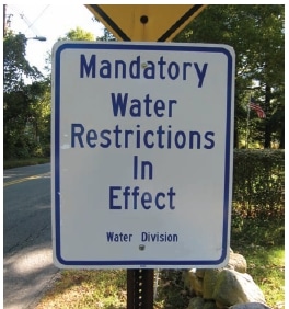 Outdoor water restrictions and bans: Many communities implement water bans in the summer that severely limit or prohibit outdoor watering.
In Conclusion
 Beaches are one of the most traditional and enjoyable means of summer entertainment for families and individuals, and they provide a plethora of recreational activities for all ages. Protecting our beaches and recreational waters is imperative to the health of our nation’s citizens and economy, and we are fortunate that our nation’s governmental agencies and local communities proactively work to maintain the health of our waters. We as individuals can also help to protect our beaches and waterways by reducing our personal water consumption, cleaning up after our pets, and being mindful of pesticide and fertilizer usage. Together, we can assure that present and future generations are able to enjoy our nation’s beautiful beaches.
Surf’s up!

Drought. Scarcity. Pollution. Climate change. Demand. Overpopulation. These are all issues with our nation’s water supply with which we have become all too familiar. Engineers and water systems are scrambling for solutions, and countless possibilities — some as basic as conservation and water bans and some as complicated as water reclamation and transporting icebergs — have been considered. Communities struggle to meet demand with dwindling supply and a limited budget, and many have begun to give desalination serious consideration.
Desalination, or the process of removing salt from water, used to be summarily dismissed as a supply option due to its expense and energy consumption. However, in light of the increase in water scarcity, desalination has become a feasible option for many water-stressed communities. Already commonplace throughout the Middle East, desalination plants are now popping up all over southern California and Texas. Let’s look at some facts about global desalination:
Dubai sources over 98% of its potable water supply from desalination
 The most commonly utilized desalination technology is reverse osmosis (RO), which was invented in California in the 1950s. RO uses high pressure to force water through fine membranes that leave the salt behind. For every two gallons of salty water, only one gallon is made available as freshwater. The whole process utilizes an exorbitant amount of energy, with energy accounting for up to half the total cost of desalination. In fact, desalinated water costs about $2,000 per acre-foot, which is approximately the amount of water used by a family of four in six months. Because less salty water requires less energy for processing, the most cost-effective desalination plants treat brackish, or slightly salty, water rather than seawater.

There are some environmental concerns surrounding desalination as well. The highly concentrated salt brine left behind requires disposal. However, because it is twice as dense as seawater, it sinks to the ocean floor and spreads, suffocating bottom-dwelling marine life. Therefore, the brine byproduct must be mixed with freshwater, typically in the form of treated wastewater or cooling water from a power plant, prior to being released into the ocean. In addition, fish and other marine life are often sucked toward the intake pipes where they are killed on the intake screens (impingement), and smaller marine life, such as plankton, larvae, and fish eggs, pass through the screens and are killed during the desalination process itself (entrainment). Fortunately, there have been some recent innovations to address these concerns. For example, subsurface intakes pull seawater from beneath the seafloor, virtually eliminating impingement and entrainment. An added bonus to subsurface intakes is the fact that the sand acts as a natural filter that pre-filters the water, reducing the plant’s chemical and energy usage.

This summer, HydroRevolution, a subsidiary of San Francisco-based agricultural and commercial water producer WaterFX, announced its plans to build California’s first commercial solar desalination plant in the state’s heavily agricultural Central Valley. The plant will run solely off solar thermal energy and will utilize Aqua4, a new desalination technology that produces only solid salt and freshwater, with zero excess discharge. In addition, it will utilize unusable irrigation water from a 7,000-acre ditch rather than seawater. The plant will provide the necessary freshwater for the area’s irrigation needs without the energy consumption or concentrated briny discharge of traditional desalination plants. Admittedly, having the 7,000-acre ditch from which to draw the water helps immeasurably, and isn’t an option for most other areas.
But desalination isn’t only being used in the southwestern part of the country. In Massachusetts, the Town of Swansea recently opened the first publicly held desalination facility in the Northeast. A coastal town, Swansea experienced a population boom that led to groundwater supplies running low, which in turn allowed seawater to seep into the aquifers. The result was a water crisis that forced the enactment of water bans, steep fines – and even left 30% of the town without water for a brief period one summer.
According to Robert Marquis, who has acted as Swansea’s water manager for over 40 years, “We just couldn’t support a burgeoning population or commercial growth,” he said. “Anything that came into Swansea, we were objecting to it if it was going to be water intensive.”
Designed with the help of Tata & Howard’s own John Cordaro, P.E., the Swansea desalination facility has been online for over a year, and took home a third place global finish at the 2014 Global Water Awards, losing only to Dubai, Singapore, and Sorek, Israel.

There is one matter with RO that, while a non-issue in sunny southern Californian, is a primary concern to the Northeast: RO filters are delicate and highly intolerant of ice, and cease being functional below 36°F. To address this issue, Swansea installed two miles of pipes in order to sufficiently heat the incoming river water prior to its entering the plant.
For water-stressed Swansea, desalination has been a successful solution. But nearby Brockton, Massachusetts has not realized the same benefit from their desalination facility. Costing roughly $120 million, the plant was constructed to utilize brackish river water as opposed to seawater, which Brockton officials believed would make the whole process affordable. However, seven years later, the water produced by the Brockton desalination plant is still too expensive, so the city has turned to a local lake as its source, leaving the costly desalination plant largely in disuse.
While desalination is heavily utilized throughout the Middle East, it has only recently come under serious consideration in the United States. As water scarcity increases due to population growth, climate change, and growing demand, alternative water source options are receiving close attention. Once not even considered due to energy costs and environmental concerns, desalination has become a frequent and sincere topic of conversation for meeting future needs. And with further advances in technology that address both energy usage and environmental impact, there remains a strong possibility that desalination could become a widely acceptable solution nationwide. Now if folks could just get on board with water reclamation…
The Bridge of Flowers, Shelburne Falls, MA
 Built in 1908 by the Shelburne Falls and Colrain Street Railway to transport people and freight to the mills in Colrain, the bridge was already out of use by 1927 when the railway company went bankrupt. However, even though it was no longer being utilized for any type of traffic, the bridge could not be demolished because it carried a water main between the towns of Buckland and Shelburne Falls. After seeing the bridge blanketed in weeds, a woman named Antoinette Burnham was inspired to turn the bridge into a lovely garden, and the community fully supported her whimsical idea. The Shelburne Woman’s Club and other women’s clubs in the town financed the project.
In 1981, the Women’s Club spearheaded a fundraising campaign for bridge repairs and the Club, along with the Towns of Buckland and Shelburne, bridge owner Shelburne Falls Fire District, the Shelburne Falls Area Business Association, and the Franklin County Planning Department, worked together to hire a planner for the project. The engineering study estimated the cost of repairs and restoration to be $580,000, which was raised through fundraising, a Massachusetts Small Cities Community Development Block Grant of $290,000, and appropriation of $100,000 from the Shelburne Falls Fire District. During restoration in 1983, the water main was replaced, and every single plant, tree, and shrub was carefully removed and tended by private citizens.
Today, care of the living bridge is managed by a head gardener, her assistant, and countless local volunteers. The blooming bridge boasts over 500 varieties of annuals and perennials and is open to the public from early spring through late fall.
East Haddam Swing Bridge, CT
 Connecting the towns of Haddam and East Haddam, Connecticut via Route 82 over the Connecticut River, the East Haddam Swing Bridge is believed to be the longest swing bridge of its kind in the world. The 881-foot long steel-truss swing, or opening, bridge is constructed of two separate spans that swing open on every half and full hour to allow recreational water vehicles to pass. Officially opened on June 14, 1903, the East Haddam Swing Bridge celebrated its centennial celebration on June 15, 2013 with an antique car parade.
Claiborne Pell Bridge, Newport, RI
 Constructed to connect the popular summer tourist town of Newport to Jamestown, RI, the Claiborne Pell Bridge is the largest suspension bridge in New England. Its main span is almost 500 meters, total length is about 3,500 meters, and its main towers stretch over the Narragansett Bay at 120 meters. Originally named the Newport Bridge, the bridge was renamed the Claiborne Pell Bridge in 1992 in honor of United States Senator Claiborne de Borda Pell, who was the longest serving senator from Rhode Island and the force behind the 1973 Pell Grants, which provide financial aid to college students.
Bailey Island Bridge, Harpswell, ME
 Built in 1927, this unique bridge connecting Bailey Island and Orr’s Island in Maine is constructed of granite blocks stacked atop one another with no mortar — the bridge is entirely held together by gravity. Bailey Island Bridge is, in fact, the only cribstone bridge in the world. Its unique construction lends the bridge incredible strength, allowing it to withstand the fiercest storms with minimal maintenance throughout the years, while still allowing strong currents and tides to easily flow through it. Added to the National Register of Historic Places in 1975, Bailey Island Bridge is a must visit for any local bridge enthusiasts.
Gold Brook Bridge (Emily’s Bridge), Stowe, VT
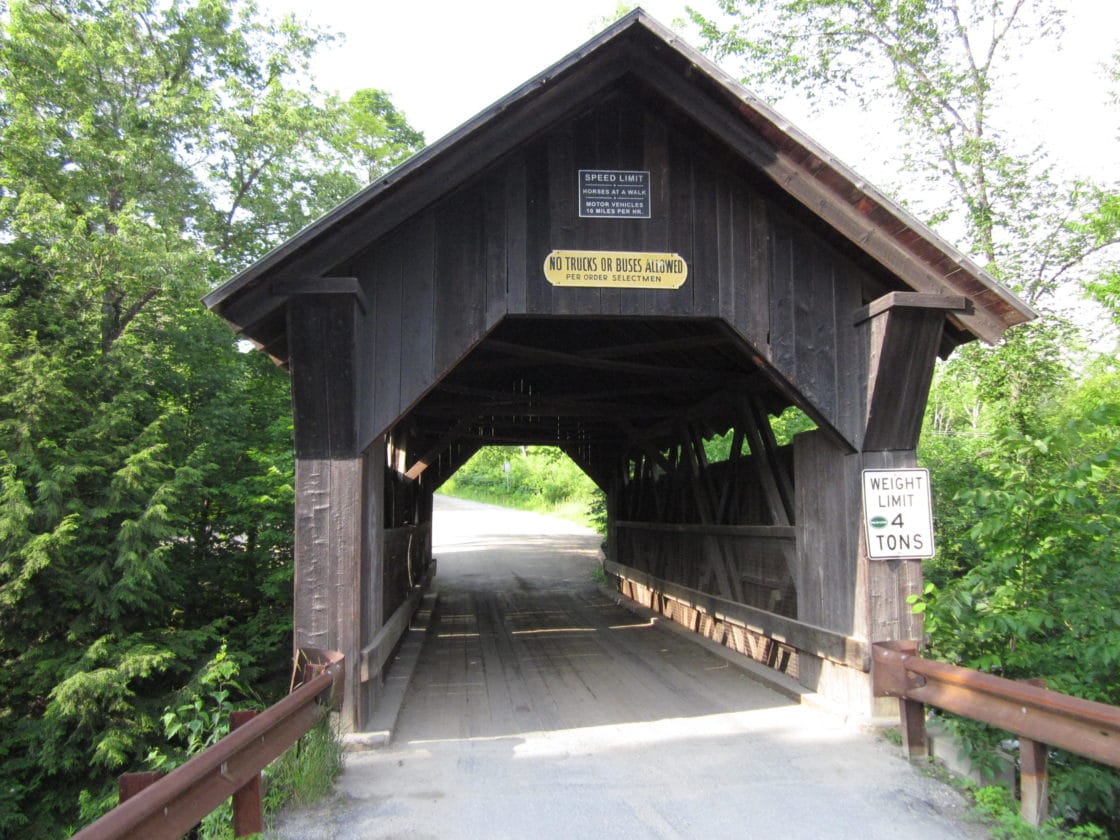 While there are many quaint, picturesque covered bridges throughout New England, Gold Brook Bridge is unique among them. Constructed in 1844, the 50-foot long single-lane structure, dark and weathered, is purported to be the home of a less-than-friendly ghost named Emily. There are two tales about Emily, and neither has been confirmed. In one version, the beautiful young woman and her lover made plans to meet at the bridge and elope. When the young man never showed, Emily was so overcome with grief that she tied a length of rope to the bridge rafters and hanged herself. In the other version, Emily and her fiancé planned to marry in the town church. Donning a red dress, Emily waited at the church in vain, as her betrothed never showed. Distraught and angered, Emily fled the church in the family wagon, whipping the horses into a frenzy. As she approached the bridge, she failed to negotiate the turn, sending wagon, horses, and jilted bride into the brook, killing all.
To this day, many local residents swear by Emily’s ghostly existence. There have been many reports of scratches and handprints appearing on vehicles that traverse the bridge at night, and people who are brave enough to venture into the structure on foot have heard screams, laughter, swinging rope, footsteps, and have experienced many technological failures. Cameras turn off, some photos come out blank, and mysterious orbs and images appear in other photos. Females who enter the bridge have felt burning scratches on their arms and backs, and many have seen Emily’s apparition calling for help.
Contoocook Covered Railroad Bridge, Contoocook, NH
 Officially opened in 1850, the Contoocook Covered Railroad Bridge is the oldest of eight surviving covered railroad bridges and four surviving double-web town lattice railroad bridges in the country. The bridge survived a flood in 1936, a hurricane in 1938, and has undergone many repairs and renovations; however, it is still considered to be the most original structure of its type, as the few others remaining have all undergone major structural modifications. It was added to the National Register of Historic Places in 1980.
The New Portland Wire Bridge, New Portland, ME
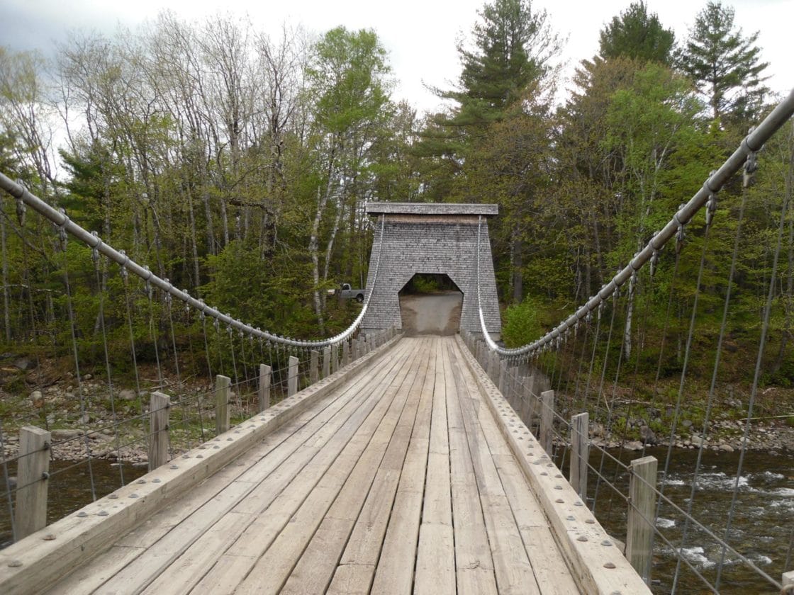 Nestled in a rural setting in central Maine, the New Portland Wire Bridge is believed to be the only remaining wire (suspension) bridge in the nation. Constructed around 1864 to span the Carrabasset River, it has a single lane constructed of wooden planks, original shingle-covered towers and 4-inch steel cables anchored by 30-ton concrete and granite blocks, and a weight limit of three tons. The bridge, last rehabilitated in 2010, is decorated with lights around the holidays and is a popular place to take photos. It was added to the National Register of Historic Places in 1970.
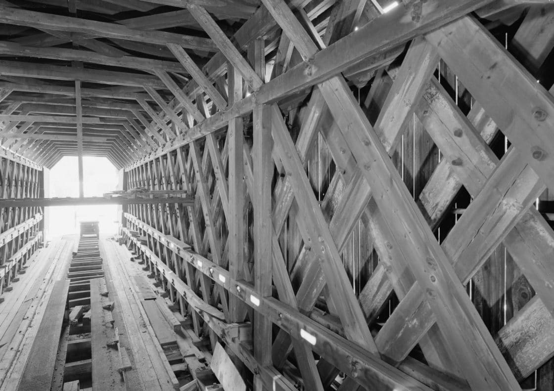
Keystone Arches, Western MA
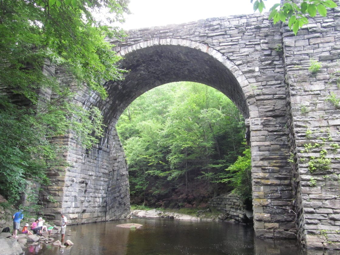 Tucked away in western Massachusetts stand the first keystone arch railroad bridges built in the nation. With heights up to 70 feet, these amazing structures were completely dry laid in the mid-1800s and designed to carry locomotives of that time, which weighed about 12,000 pounds. Incredibly enough, some of the arches are still in use today but carry locomotives that are about 430,000 pounds – or 35 times heavier than their predecessors. In 1912, parts of the railroad line were relocated, and the bridges that were bypassed have stood in place with absolutely no maintenance since that time. Accessible only by hiking trails, these magnificent arches make an enjoyable daytrip for nature enthusiasts and families.
Leonard P. Zakim Bunker Hill Bridge, Boston, MA
 Designed to combine Boston’s historic past with its future, The Leonard P. Zakim Bunker Hill Bridge was named in honor of civil rights activist Lenny Zakim. With its inverted Y-shaped towers that reflect the shape of the Bunker Hill Monument in neighboring Charlestown and its cables that are reminiscent of a ship in full sail, the bridge memorializes Boston’s colonial and shipbuilding history while maintaining a modern, sleek appearance. At 183 feet wide and 1,432 feet long, it is the widest cable-stayed bridge in the world and carries ten lanes of traffic in and out of the bustling city.
Thread City Crossing or “The Frog Bridge”, Willimantic, CT
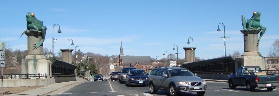 Admittedly, Thread City Crossing over the Willimantic River in Connecticut is quite unremarkable — save for the four 11-foot tall frogs perched atop massive spools of thread. Affectionately known as The Frog Bridge, the 500-foot structure was built in 2000 and shows that the good folk of Willimantic certainly have a sense of humor. While the spools of thread were incorporated into the design in order to commemorate the Town’s history as a leading thread manufacturer of the 19th and 20th centuries, the frogs were included for a much cheekier reason.
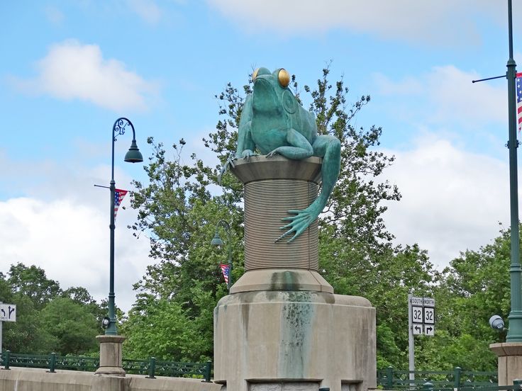 In 1754, the townsfolk of Windham, CT (now Willimantic) were apprehensive and jittery. You see, Windham’s finest had joined Colonel Eliphalet Dyer’s regiment to fight in the French and Indian War, and those left behind were terrified. People slept lightly, with muskets tucked next to their beds, in anticipation of an imminent Indian attack. One very hot summer night, with the Town in the midst of a dreadful drought, the townsfolk were roused by an unearthly sound, described as “a shrieking, clattering thunderous roar.” Some believed the dreaded Indian attack had finally come, while others believed that Judgment Day was upon them. The townspeople ran into the streets, some falling to their knees to pray while others blindly shot their muskets into the night. A group of braver souls went off in search of the marauders, to no avail.
When the sun rose the next morning, the villagers were finally able to see what had caused the “terrifying” commotion. A millpond, two miles east of the village center, had almost completely dried up during the summer drought, and apparently the local bullfrog community had engaged in a turf war to claim ownership of the dwindling water supply. Hundreds of bullfrog carcasses riddled the perimeter of the pond, and, from that day forward, the Town became infamously — and, to the townsfolk, embarrassingly — known as the scene of the “Battle of the Frogs.”
Do you know of any bridges in New England that we should have included on our list? Let us know! We’d love to hear from you.
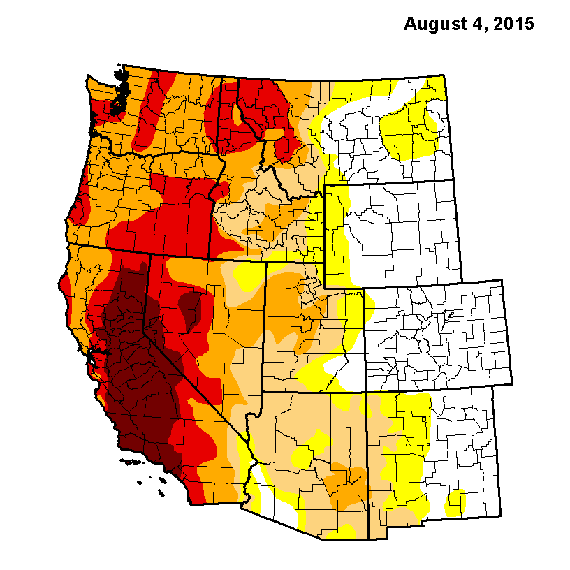
Drought. Every day, there are multiple news stories about the historic drought affecting America’s west and south. In April, Governor Jerry Brown mandated that Californians cut their water usage by 25%. Almond growers are being lambasted for growing a thirsty crop, golf courses are allowing their greens to turn into browns, and aquifers are being depleted at a rate far greater than they are being replenished. The outlook is bleak. Seven states are literally running out of water, and scientists are scrambling to try to address the unprecedented drought.
Yet in the midst of all of this, New Englanders are rather lackadaisical. After all, Lowell, Massachusetts just experienced the snowiest winter on record with an unprecedented 120.6 inches, earning the city the title of “snowiest city in the United States” for the 2014-2015 winter, and the summer has been fairly mild. On August 6, the USGS drought monitor showed a couple of areas of mild drought, but New Englanders have come to expect regular, soaking rains, and nobody seems too concerned. After all, New England isn’t affected by the exceptional drought of the west coast. Or is it?
Extreme Weather on Both Coasts

Sir Isaac Newton’s Third Law states that for every action, there is an equal and opposite reaction; and while the law refers to motion, it can also be applied to weather. The severe drought and high heat of the west is directly related to the cold and snow in the northeast, and both extremes have been attrributed to global climate change. In the period of January to March of 2015, New England experienced its coldest winter on record. Providence, RI, Worcester, MA, and Hartford, CT broke all cold records during that time, while Boston, MA experienced its third coldest winter on record, with its top two coldest periods dating all the way back to the 1800s. On the opposite coast, Sacramento, CA experienced its hottest March on record, with temperatures rising to those that are more typical to May than March. Weather balances the atmosphere, so when an extreme takes place in one geographic location, the opposite extreme will occur somewhere else in the world.
“Ridiculously Resilient Ridge”

Stanford University Ph.D. candidate Daniel Swain, who writes The California Weather Blog, coined the alliterative nickname for the high-pressure area that sits over the eastern Pacific Ocean for months at a time. And, like the Ridiculously Resilient Ridge itself, the name has stuck. The ridge is basically a mountain of air that stalled off the coast of California and British Columbia, causing any storms that would typically hit California to trend farther north instead to the Alaskan panhandle and northward. The trough, just as alliteratively coined the “Terribly Tenacious Trough” by Jennifer Francis, Research Professor at Rutgers University, in turn sat over the east coast, bringing with it unusually cold, wet weather. This weather pattern, which would be typical if it lasted just a short period of time, has been extreme in that it has been incredibly persistent, developing for months at a time since 2012. In addition, climatologists are scratching their heads over it, as there is no clear reason why it has been so persistant.
Economic Impact
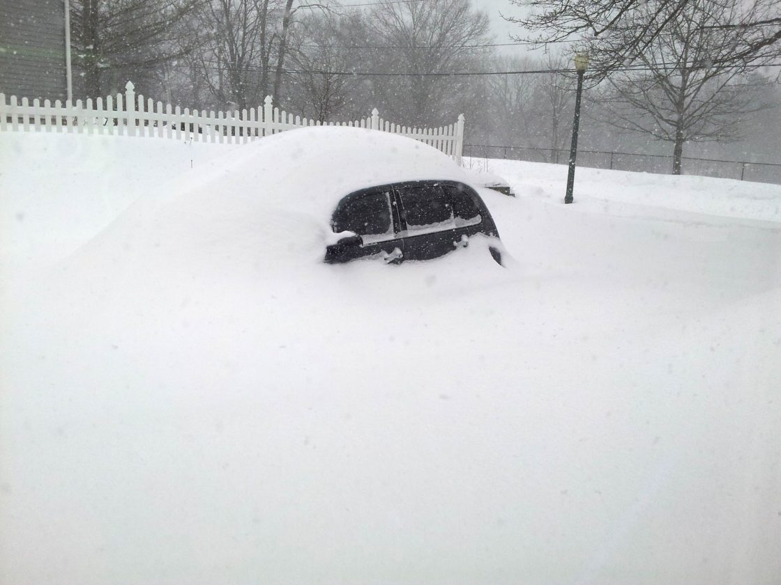
New Englanders took a significant economic hit during the extreme winter of 2014-2015 due to exhausted snow removal budgets, damaged property, and high utility and heating bills. Ice dams and roof issues from the excessive amount of snow caused damage to many homes, and insurance companies are still reeling from the claims processed over the winter, which also included higher than average vehicle and accident claims. Many accidents were attributed to the severe winter and snowfall, and to the gargantuan snow piles that made driving and maneuvering in parking lots even more treacherous. And even more problems ensued when the snow began to melt in the spring.
Flooding
Flooding is not just caused by extreme rainfall but is in fact influenced by many factors, such as soil conditions and sea level. In the northeast, excessive precipitation, like the record snowfall experienced this past winter, increases soil moisture content, which in turn increases the potential for flooding. In addition, northeast sea levels have risen over a foot since last century, which already puts New Englanders at increased risk for flooding.
Food Supplies

California grows more food for consumption in the United States than any other state. In fact, nearly half of all the fruits, vegetables, and nuts grown in the entire country are grown in California, and the state is the fifth largest supplier of food in the world. Growing over 450 different crops, California is the exclusive U.S. producer of many crops including almonds, artichokes, clover, dates, olives, pistachios, and raisins. In addition, California also produces almost all of the grapes, lemons, lettuce, and tomatoes grown in the nation.
Prices of these crops have already risen, and are expected to rise even more. 80% of the water used in California is used by farmers and ranchers, and with the exceptional drought, many farmers have had to leave their fields fallow or pay to pump water from the ground. The economic hits to farmers are passed onto consumers, resulting in higher priced produce and nuts for the rest of the nation. If the drought continues, California farmers may be forced out of business, resulting in national food shortages. And over on the opposite coast, Florida experienced freezing temperatures that affected the 2014-2015 orange crop, resulting in the smallest yield of oranges since the 1964-1965 season.
Looking Ahead

At this time, forecasters are hoping that the extreme drought in California may be coming to an end. The combination of El Nino and “the blob” create a high possibility for a temperate, wet winter in the Pacific Northwest, and California residents and businesses are keeping their fingers crossed — as should New Englanders. Once again referring to Newton’s Third Law, we can safely assume that a mild, wet winter for California would likely produce a mild, dry winter for the east coast. And that is something the whole nation should celebrate.
Summer is here, and with it comes long, lazy days, school vacation, and, of course, family trips. When the beaches, amusement parks, and movie theaters start to get stale, why not take a water or wastewater field trip to explore the inner workings of our nation’s water and wastewater infrastructure? We’ve assembled five excellent water and wastewater field trips that are right here in beautiful New England. These trips provide STEM (Science, Math, Engineering, and Technology) education while also being engaging and fascinating. And these trips aren’t just for budding engineers. Half of all STEM jobs do not require a college degree and pay higher than non-STEM jobs with similar educational requirements.
Top 5 Family-Friendly Water and Wastewater Field Trips in New England
1. Deer Island Wastewater Treatment Plant, Boston, MA — Operated by the Massachusetts Water Resource Authority (MWRA)
The MWRA offers tours of its Deer Island Wastewater Treatment Plant on Tuesdays and Fridays from April through November. All tours begin at 9:30 a.m. and are open to adults and kids in grades 7+. But the treatment facility isn’t the only attraction at Deer Island. With 60 acres of natural open space, Deer Island offers plenty to do for the entire family, including five miles of public walkways and trails for strolling, jogging, sightseeing, picnicking, fishing, and cycling. There are ten landscaped overlooks with sweeping views of the Boston skyline and islands, handicapped accessible paths, and low impact development (LID) features including low-maintenance, native plant species. The public access area is open year-round, from sunrise to sunset. https://www.mwra.com/03sewer/html/sewdi_access.htm
2. Waterworks Museum, Boston, MA
The Waterworks Museum is located on the site of the original Chestnut Hill reservoir and pumping station and provides regional information on clean water, health, engineers, and architecture. In addition to providing the history of waterworks in the City of Boston, the museum’s Great Engines Hall houses three historic, steam-powered pumping engines, and walking tours of the reservoir itself are available. The architecturally breathtaking museum is open Wednesday – Sunday from 11am-4pm year-round, with extended “Waterworks Wednesday” hours until 9pm from April through November. Waterworks Wednesdays feature authors, concerts, and guest speakers in addition to regular tours and learning opportunities. https://waterworksmuseum.org
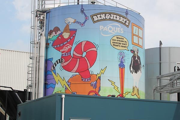
3. Ben & Jerry’s, Waterbury, VT
From its humble beginnings in a warehouse in Burlington, VT, Ben & Jerry’s has grown to a highly successful global corporation. And while the company has exponentially increased in both size and reach, it has remained loyal to its local roots. So when it was determined that the waste created in their Waterbury, Vermont location would overload the local wastewater treatment facility, they instead decided to funnel it to two of their local dairies where it is processed in a methane digester along with other farm waste. The result? Enough biomass energy to power the farms. Unfortunately, tours of the methane digester are not available. But that’s OK, because Ben & Jerry’s offers tours of its ice cream manufacturing facility, and these tours include education on the dairy waste – as well as ice cream samples. https://www.benjerry.com/about-us/factory-tours
BONUS: Building on their commitment to green energy, Ben & Jerry’s is the first ice cream company in the world to power one of its manufacturing plants using its own waste. Located in Hellendoorn, Netherlands, the “Chunkinator” is a BIOPAQ®AFR Biodigester containing over 24 billion natural micro-organisms that turn the plant’s own ice cream waste and wastewater into biogas that fuels the plant. To date, the brightly-painted Chunkinator has produced enough power to make over 16 million pints of Ben & Jerry’s ice cream. So if you happen to be in the Netherlands this summer, be sure to swing by to check it out! https://brightfuture.unilever.com/stories/423955/THE-CHUNKINATOR–Turning-ice-cream-into-energy.aspx

4. Sebago Lake Water Treatment Facility, Standish, ME
Maine’s Sebago Lake Region is a popular summer destination that offers camping, fishing, boating, hiking, shopping, dining, live music, theatre, and much more, and families travel from all over the country to enjoy the region’s pristine, natural beauty. While you are there, you can add a little education into the family trip by visiting the Portland Water District’s Sebago Lake Water Treatment Facility. Tours are available on the first and third Thursdays of each month, beginning at 9:30am and lasting approximately two hours, and include both the facility and the lab. Due to the technical, complex nature presented, tours are recommended for high school age and older. Located on a 10-acre site in Standish, Maine, the state-of-the-art facility utilizes screening, ozonation, UV light treatment, chloramination, fluoridation, and corrosion control. https://www.pwd.org/tours
5. Stamford Water Pollution Control Authority (WCPA), Stamford, CT
The Stamford Water Pollution Control Facility processes wastewater from Stamford and Darien, CT and discharges the treated water into the Stamford Harbor. The site has been treating wastewater since 1900, with the first plant being built in 1943. Upgraded in 1976 and again in 2006, the facility is manned 24/7/365. In response to multiple requests for tours, WPCA began offering regular public tours in 2013. Held on the second Friday of each month at 12:30pm (weather permitting), the tour includes classroom education on the wastewater treatment process followed by a walking tour of the plant to see it in full operation. Total tour time is approximately one and a half hours. In addition, comprehensive student or group educational tours for all ages can be scheduled in advance for Monday through Friday between the hours of 8am and 3pm. https://www.stamfordwpca.org/public-outreach.aspx
BONUS: While visiting Stamford, families can also visit Cove Island Park, a beautiful 83-acre beach and park on Long Island Sound that offers plenty of space for walking, biking, picnicking, or swimming, or they can even catch a ferry over to New York City.
Summer in New England is simply perfect for day tripping, and the education provided by a water or wastewater treatment plant tour is invaluable. So check out one (or more) of these five water and wastewater field trips, and let us know what you think. Happy summer!
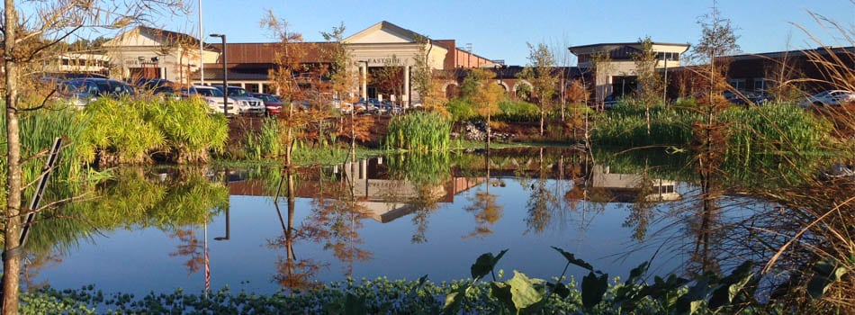
Water storage tanks are an integral part of public water systems, providing storage of potable water as well as emergency sources for fire protection. Set high enough above the ground to sufficiently pressurize a water supply system for emergency distribution, these highly visible structures are often cylindrical and painted in neutral or pastel colors. Water storage tanks are readily seen while driving along highways, and often don’t make much of an impression. However, there are some water storage tanks around the world that are quite eye-catching, many of which have been written about. And while these tanks are certainly fascinating, we thought it would be fun to take a look a little closer to home.
The 12 coolest water storage tanks in New England
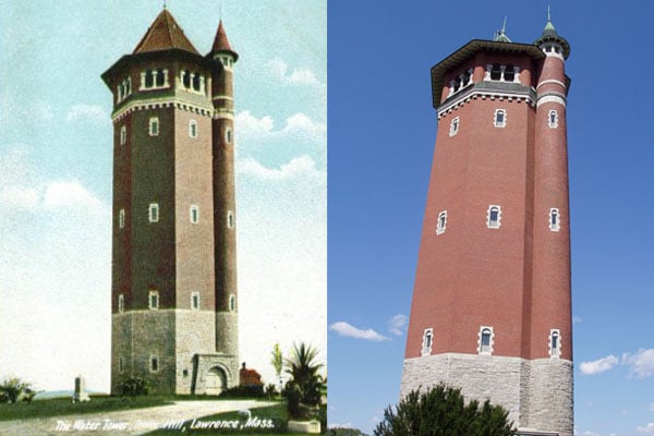
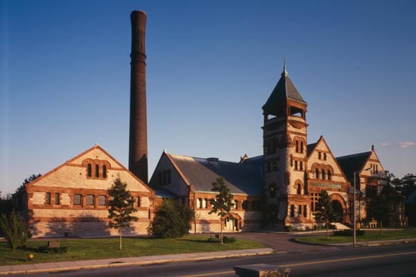
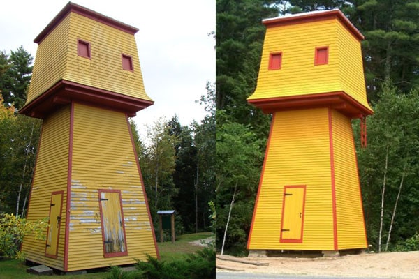
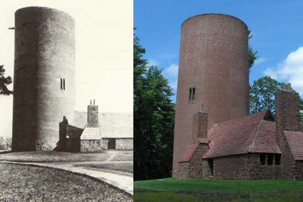
1. Tower Hill Water Tower, Lawrence, MA
The High Service Water Tower, also called Tower Hill Water Tower, was built in 1896 as a high pressure standpipe. The tower, constructed of red brick with granite trim around a steel standpipe, stands 157 feet and was designed by George G. Adams, a noted local architect. The octagonal, Romanesque structure includes a balcony capped by a chateauesque roof, round-arch windows, and a round staircase along one side. It was added to the National Register of Historic Places in 1978 and named a Water Landmark by the American Water Works Association (AWWA) in 1979.
2. Cathance Water Tower, Topsham, ME
The Cathance Water Tower located in Topsham, Maine was built in 1906 to serve the Rogers’ family household and farm. The Tower is 29-feet tall with a 12-foot 4-inch square base and originally held over 5,000 gallons of water. In January 2001, the Cathance Tower was added to the National Register of Historic Places as a locally significant and rare surviving domestic water supply structure. Also in 2001, the Town of Topsham received grant money to restore the Tower, and the restoration was completed in 2005. The stylized structure is essentially unaltered from its original state and is now owned by the Town.
3. Salem, MA
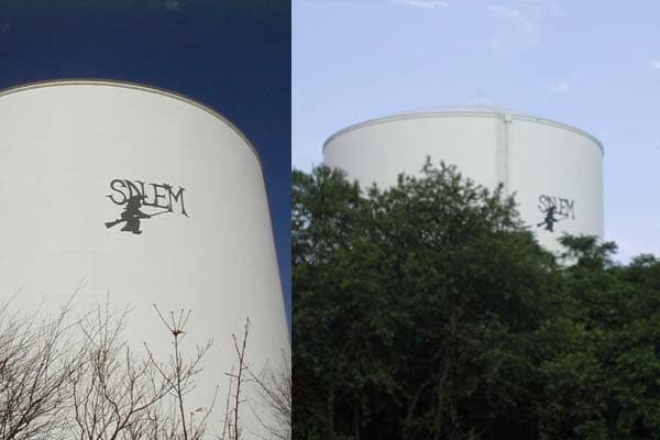
The water storage tank in Salem, MA is rather ordinary save for one very important detail: there is a silhouette of a witch riding on a broomstick painted onto the side of the tank. Salem is well known for its brutal Salem witch trials of 1692, during which 20 innocent people were executed, and to this day Salem gets much of its cultural identity from the trials. During Halloween, Salem attracts thousands of tourists dressed in witchy garb as well as people interested in the paranormal and witchcraft.
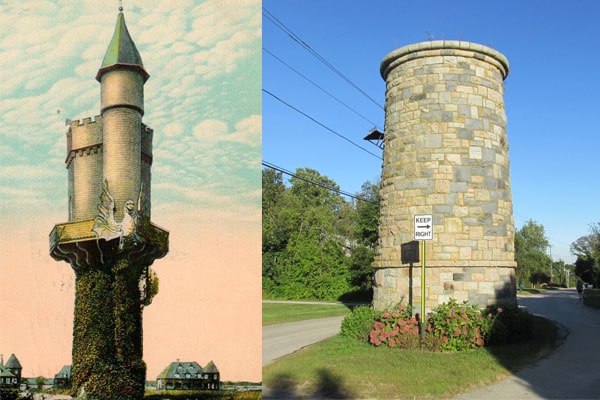
4. Earles Court Tower, Narragansett, RI
The Earles Court Tower was built between 1887-1888 in order to serve the summer community in the popular seaside resort town of Narragansett, Rhode Island. The original tower included a cylindrical stone base upon which was constructed a wooden superstructure that included a balcony and a giant, ornate griffin. In 1928, a strong storm decimated the wooden structure, but the stone base stands to this day. There is currently a grassroots committee of residents who are trying to raise funds to restore the tower to its former glory.

5. Pepperell Park, Saco, ME
The stone water tower in Pepperell Park, Saco, Maine was constructed in 1887 in order to irrigate Pepperell Park. Horace Wadlin, architect of six other buildings in the Biddeford and Saco area including the historic Dyer Library, designed the charming tower, which still exists today but is no longer functional.
6. Fort Ethan Allen, Essex, VT
The 80-foot tall water tower constructed in 1893 at Fort Ethan Allen was the first of 100 structures to be built at the fort. The tower boasts a 21-foot diameter base that tapers to a conical slate roof that used to be adorned with a weathervane, which has since vanished. The exterior of the tower has stood the test of time remarkably well, as has the intact 50,000-gallon steel tank inside the structure. Because the fort did not have electricity until 1905, water was originally pumped to the tower by steam engines. Unfortunately, the interior circular wooden stairway that winds its way to the observation deck was declared unsafe in 2008, so tours are no longer allowed. There is currently an effort underway to raise an estimated $250,000 to rehab the tower and reopen it to the public.
7. Avon Farms School, Avon, CT
The water tower and forge at the entrance to the all-boys Avon Old Farms School in Avon, CT were built in 1922. The English Cotswold and Tudor-styled water tower is cylindrical in shape and constructed of red sandstone and brick, and was operational until 1976 when cisterns were placed underground. It was fully restored in 2012 and now functions as an art gallery and reception venue.
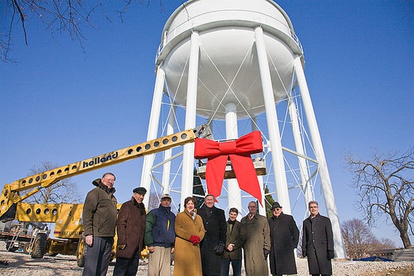
8. Roger Williams University Gift, Bristol, RI
To onlookers, the Bristol, RI water storage tank doesn’t appear to be anything noteworthy. After all, it’s a fairly standard elevated steel tank painted basic white. But what makes this water tower special is how it came to be. During some onsite construction in 2008, Roger Williams University encountered a problem: low water pressure. But instead of bringing in pressure booster pumps to campus and leaving the town to fend for itself, the university decided to donate $1 million to the town for a new water tower. The water tower was constructed in 2009, and on December 30 of that year, it was formally presented to the town at a ceremony — complete with a giant red bow.

9. Telegraph Hill, Hull, MA
Telegraph Hill is part of Fort Revere Park, a 6-acre historic site located on a small peninsula in the town of Hull, Massachusetts. Telegraph Hill was originally used as a fort in 1776 to defend the port of Boston, and the first telegraph tower was built in 1827. In 1903, the United States Government hired the Hennebique Construction Company to build a 120-foot high, 25-foot diameter reinforced concrete tower housing a 118,000 gallon steel water storage tank to serve Fort Revere. The tower was the first reinforced concrete water tower in New England, and it also served as an observation tower for the Army. The tower was restored in 1975 and was designated an American Water Landmark in 2003. Telegraph Hill was added to the National Register of Historic Places in 1976.

10. Cochituate Standpipe at Fort Hill, Roxbury, MA
Like Telegraph Hill, Fort Hill in Roxbury, Massachusetts was originally used as a fort to defend the area during the Revolutionary War because of its high location. In 1869, the Cochituate Water Company constructed a 130-foot tall brick tower on the site to house an 80-foot tall high pressure water tank and to provide visitors with a clear view of Boston and the surrounding area. The gothic tower, known as the Cochituate Standpipe, is architecturally stunning and in beautiful condition – even the original spiral staircase that wraps around the water tank still remains. The entire neighborhood of Fort Hill, which is sometimes referred to as Highland Park, was listed on the National Register of Historic Places in 1989.
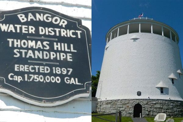
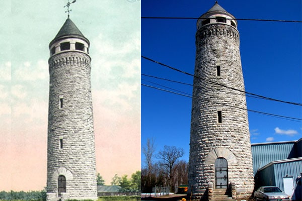
11. Thomas Hill Standpipe, Bangor, ME
The 50-foot tall, 75-foot diameter riveted steel tank, which holds 1.75 million gallons of water, was designed by A.B. Tower of Holyoke, Massachusetts and was constructed in 1897 by the New Jersey Steel and Iron Company atop Thomas Hill in Bangor, Maine. The tank is enclosed by a wooden jacket and has been continually used for its original purpose of regulating the town’s water pressure and providing an emergency source since its construction. Bangor Water District assumed ownership of the standpipe in 1957 and it was added to the National Register of Historic Places in 1974. It is also designated an American Water Landmark by the AWWA. Fun fact: the Thomas Hill Standpipe is within walking distance of renowned author Stephen King’s home, and is commonly believed to be the inspiration for the haunted standpipe in his best-selling novel It.
12. Lawson Tower, Scituate, MA
153-foot tall Lawson Tower was constructed in 1902 to hide a 276,000-gallon water tank from the view of Boston multi-millionaire Thomas W. Lawson’s “Dreamworld” estate across the street. Lawson himself paid for the structure, and he spared no expense. The tower was built in the style of a European castle turret with 123 steps to the ornate top, in which there are ten bells ranging in size from 300 to 3,000 pounds. The bells could be played from either the bell room or from a console in the clavier room. The tower is not only aesthetically pleasing but also provides sweeping views of the area, allowing visitors the ability to see all the way to Provincetown on a clear day. It was designated an American Water Landmark by the AWWA in 1974 and was added to the National Register of Historic Places in 1976. The Scituate Water Company stopped using the interior tank in 1988, and the tower is now a popular tourist attraction.
10 Best Low Impact Development Stormwater Practices
Stormwater runoff is the number one source of water pollution in the country, and a major threat to clean water in many New England communities. Over the years, we have paved, constructed, and developed the land to the point that the natural landscape is decimated. Where snow, sleet, and rain would normally land on forests and grass and be filtered by layers of dirt and rock, it now washes off parking lots, roads, driveways, rooftops, and other hard surfaces, known as impervious cover, and picks up pollutants such as oil, trash, sediment, bacteria, fertilizer, oil, and road salt along the way. This heavily polluted, untreated water then makes its way into streets and storm drains and subsequently into rivers and lakes that supply our drinking water.
In Texas and Oklahoma this week, we’ve seen the devastating and deadly effects of stormwater runoff. Because the absorbent grasses and dirt have been mostly covered over by pavement and buildings, heavy rains now run off streets, roofs, and driveways, overwhelming drainage systems and, in extreme weather, flooding homes. And in New England, stormwater runoff has not only contributed to water pollution and flash flooding, but also to beach closures, algae blooms, and soil erosion.
What is Low Impact Development?
Low Impact Development (LID), also known as green infrastructure, is a stormwater management approach that maintains natural hydrology during site development. LID minimizes impervious surfaces and utilizes existing natural site features along with conservational controls to manage stormwater. In LID, stormwater is viewed as a resource rather than a waste product, and the site is developed with this key concept in mind. Often, LID replaces traditional stormwater management practices that focus on moving stormwater off-site with curbs, pipes, and ditches.
LID is useful for creating functional, attractive, and environmentally friendly residential, commercial, and industrial sites, and is both sustainable and cost-effective. Some of the benefits include improved water and air quality, reduced stormwater runoff volume, increased natural habitat and recreational space, increased property values, improved groundwater recharge, and community beautification. Below we have compiled a list of ten LID stormwater practices that are most effective in managing stormwater in New England.

1. Rain Gardens
A rain garden is typically situated close to the source of runoff and utilizes plants that are able to withstand extremes of moisture as well as excessive nutrients such as nitrogen and phosphorus. By slowing stormwater as it travels downhill, rain gardens provide opportunity for stormwater to infiltrate and also inhibit erosion. While rain gardens provide habitat for wildlife and are an attractive landscaping addition, it’s what’s beneath them that makes them an LID rain garden. Plants and soils are specifically chosen and engineered to clean stormwater by reducing nutrients and overall sediment loads. Multiple rain gardens are often spread over an area, cumulatively controlling the volume and improving the quality of stormwater runoff.

2. Green Roofs
A green roof, also knows as a rooftop garden, is exactly what its name suggests: a roof with vegetation on it. Through evapotranspiration, green roofs remove heat from the surface of the roof and in turn the surrounding air. A green roof is easily installed on any type of building, residential or commercial, and can be as simple as a single layer of groundcover or as intricate as Fenway Park’s extensive vegetable garden. In addition to providing excellent stormwater management and improving water quality, green roofs also provide such benefits as reduced energy use and air pollution, and improved comfort and quality of life.

3. Permeable Pavement
The link between high levels of impervious surfaces and degraded water quality is indisputable, and most impervious surfaces are paved roadways. Reducing impervious surfaces is one of the key steps in improving any community’s water quality. Permeable, or pervious, pavement is designed to allow water to pass through it into the ground below where it is naturally filtered. Pervious pavement has a myriad of benefits including not only reduced stormwater runoff and replenished groundwater, but also reduction of flooding, pollutants, temperature, roadway ice buildup, and traffic hydroplaning accidents. In New England, special care needs to be taken when utilizing permeable pavement, as there is potential to compromise its effectiveness through plowing and sanding.

4. Grassed Swales
A grassed swale is an open channel designed to manage a specific water quality volume, often along roadsides and parking lots. Stormwater runoff is slowed by vegetation as it flows in these channels, allowing the stormwater to infiltrate and be filtered by the underlying soil. Grassed swales are long and shallow in shape and have plants that are both flood and erosion resistant.

5. Disconnected Impervious Surface (DIS)
DIS is a low-cost, effective way of reducing the volume and flow of stormwater runoff by directing stormwater runoff from impervious areas to graded and vegetated pervious surfaces. DIS is effective for both roofs and paved areas utilizing slightly different designs and provides both infiltration and filtration.
6. Bioretention Basins
Bioretention basins are landscaped depressions specifically designed to slow and treat on-site stormwater runoff. Typically utilized in parking lots and residential areas, these basins incorporate pollutant removal systems that naturally operate in forests. During a storm event, runoff pools above the mulch and is slowly filtered through the soil beneath before being collected by a perforated underdrain. The clean, filtered runoff is then returned to the storm drain system or local receiving waters.

7. Alternative Street Design
Alternative street design is mainly effective for new construction and takes into account all aspects of “green streets.” When building a new street, all existing hydrologic functions of the land need to be considered and incorporated in the best possible way into the design. This includes preserving wetlands, buffers, and highly permeable soils while minimizing impervious areas. Typically streets are more narrowly constructed with wide, pervious sidewalks and plenty of vegetated areas.

8. Bioretention Curb Extensions (Stormwater Bumpout)
A stormwater bumpout is a curb extension that extends the existing curb. Typically located either mid-block or at an intersection and composed of a layer of stone that is topped with flood and nutrient tolerant plants and soil, these attractive bumpouts filter stormwater while providing an aesthetic benefit to communities. The bumpout is constructed with an inlet (or curb-cut) that directs stormwater runoff into the bumpout where it can be infiltrated and filtered. The vegetation in a stormwater bumpout is short enough so as not to impact driver sight-lines.
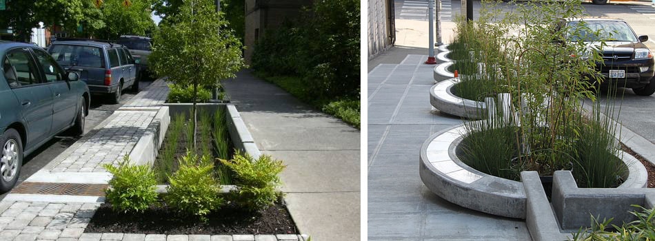
9. Stormwater Planters and Tree Boxes
Stormwater planters and tree boxes are installed in sidewalks and are designed to manage stormwater runoff from streets and sidewalks. Planters are typically sunken into the sidewalk, rectangular in shape with concrete sides, and lined with a permeable fabric. They are then filled with stone or gravel and topped with soil, hardy plants, and trees. Because they are built down into the sidewalk, runoff is directed into these planters that provide storage, infiltration, and evapotranspiration.

10. Rain Barrel/Cistern
A rain barrel collects and stores stormwater runoff from rooftops, where it can later be used to water lawns and gardens. To be effective, they must be emptied between storms and utilized by a high percentage of a community’s population. While one rain barrel holds a relatively small amount of water, a large volume of rain barrels can be extremely effective in significantly reducing the amount of stormwater entering a community’s sewer system during storms.
 A common saying here in New England is, “If you don’t like the weather, wait ten minutes.” It’s true our weather is hard to predict and this winter alone we’ve had temps as high as in the 50’s to below zero.
But when the meteorologists report that a blizzard is imminent, most New Englanders know to respect the warnings and Mother Nature.
One of the most probable and most dangerous issues that come up during a blizzard is power losses. With overhead power lines and lots of trees in the way, high winds and heavy snow more often than not will take down the power. In below freezing temps, power outages can be extremely dangerous to you and your water pipes. Here are a few tips to keep you safe this week and in future winter storms.
1. Keep the water running! Water pipes tend to freeze in temperatures below 20 degrees Fahrenheit (about -7 degrees Celsius). Prevent this by wrapping your interior pipes with foam insulation. If the temperature is dropping, leave your faucets running at a slow drip.
Run the cold water from the lowest point in the house, usually a laundry room sink or tub. Keep your drain clear of debris to prevent overflow or flooding.
The idea is to keep the water flowing constantly at a rate of about one gallon every four minutes. Do not run your hot water.
2. Layer Up! Next to the Blizzard Kit, keep a bag of warm clothes for each person in the household. If the lights are out, it will be hard to find that really warm turtle neck or a pair of warm socks or gloves…in the dark.
3. Stock a Blizzard Kit with the following: batteries, flash lights, battery operated radio/television, bottled water, toilet paper, nonperishable foods such as cereal or crackers, canned goods, a non electric can opener, a small cooler, candles, prescription medicines and any over-the-counter remedies you use regularly; and if you have young infants or toddlers – diapers, baby wipes, formula, baby food.
4. Then, stock a “Boredom” Kit, as well. Count on the power being out for at least a day or two and have some board games and a deck of cards on hand. An easily available activity kit next to the blizzard kit with arts and crafts for the kids is crucial for long periods of power loss – especially if there isn’t any television to distract them.
5. Charge all your devices. Now’s the time to get all the devices in your house fully charged and easy to find. Now is the time to add emergency numbers in your phone’s memory for easy access when you need them.
6. Finally, STAY INSIDE. However tempting it may be for kids to go out and make snow angels or play in the falling snow, use caution. Those blowing winds – both before and after a blizzard – are cold enough to cause frostbite, and snowdrifts may hide dangers children might otherwise see. Stay indoors where it’s safe, and warm!
Blizzards are serious business. Weather forecasters can only predict so much. Educate yourself and stay on top of the updates in your area. There is no harm in being overly cautious. In most cases where a blizzard is concerned, it truly is better to be safe than sorry.